%20(1).png)
%20(1).png)
7 Best Hikes Near Palm Springs You Need to Do
- The Muse Hotel
- 16 hours ago
- 12 min read

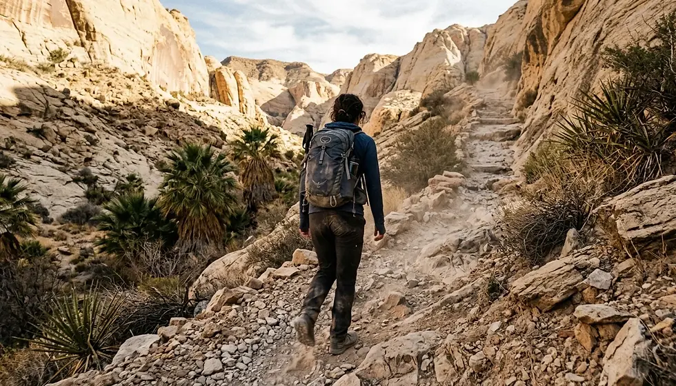
The best hikes near Palm Springs range from the easy 1-mile Andreas Canyon Trail to the grueling 22-mile Cactus to Clouds route with 10,400 feet of elevation gain.
Indian Canyons Nature Preserve offers 60+ miles of trails, including the Murray Canyon waterfall hike; entry fees are $12 per adult as of 2026.
Tahquitz Canyon Trail is a 2-mile guided loop with a 60-foot seasonal waterfall; the entry fee covers a mandatory ranger tour.
For sunrise hikes that beat the desert heat, the Araby Trail and North Lykken Trail deliver panoramic Coachella Valley views with early-morning timing.
Whitewater Canyon Preserve is a genuinely lesser-known option most visitors skip; it offers a perennial stream and canyon scenery free of Indian Canyons crowds.
The Muse Hotel Palm Springs, located about 10 minutes from Indian Canyons and the Tahquitz Canyon trailhead, puts you close enough to hit the trail before midday heat sets in.
Which Hikes Near Palm Springs Are Actually Worth Your Time?
Palm Springs hiking trails refer to the network of desert, canyon, and mountain routes accessible from the city, spanning Indian Canyons, the San Jacinto Mountains, Joshua Tree National Park, and several lesser-known preserves. Local hiking author Phillip Ferranti, who wrote the guidebook 140 Hikes In and Near Palm Springs, documents trails within a 70-mile radius. The seven routes in this guide were selected for their combination of scenery, practical accessibility, and honest fit with a weekend visit. Each one delivers something specific: shade, a waterfall, jaw-dropping elevation, or solitude.
The trail landscape divides naturally into three zones. First, the canyon floor hikes inside Indian Canyons Nature Preserve are the most accessible and the most popular, with a paid entry gate and ranger support. Second, the mountain trails above Palm Springs, including Lykken and Araby, are free, start close to downtown, and reward sunrise visits. Third, the regional day trips to Joshua Tree National Park and Whitewater Canyon Preserve require a short drive but add genuine variety to a multi-day hiking itinerary.

What Makes Indian Canyons the Best All-Around Desert Hiking Destination?
Indian Canyons Nature Preserve is the single best starting point for desert hiking near Palm Springs, offering more than 60 miles of trails across Andreas, Murray, and Palm Canyons on lands belonging to the Agua Caliente Band of Cahuilla Indians. Entry fees in 2026 are $12 per adult, $7 for seniors 62 and older, $7 for students, and $6 for children ages 6 to 12. The preserve runs ranger-led interpretive hikes on Fridays through Sundays from October through June; call 760-323-6018 for the current schedule. Three trails stand out as the best within the preserve.
Andreas Canyon Trail: Shaded, Easy, and Genuinely Beautiful
Andreas Canyon Trail is a 1-mile shaded route running alongside a perennial stream, flanked by more than 150 plant species and dense groves of California fan palms. It is the most beginner-friendly trail in the preserve and the best choice for visitors arriving mid-morning who want shade and a defined finish point. The path is wide enough for side-by-side walking, which makes it popular with couples and small groups. Arrive by 9 a.m. on weekends to secure parking close to the trailhead before the lot fills.
Murray Canyon Trail: The Best Waterfall Hike Near Palm Springs
Murray Canyon Trail is the best waterfall hike near Palm Springs for most visitors. The trail stretches between 2 and 6 miles depending on how far you push into the canyon, and the payoff is the Seven Sisters Waterfall, a series of cascades that flow most reliably from late winter through early spring following rain in the San Jacinto Mountains. Plan to go in February or March for the strongest flow. The canyon narrows as you go deeper, and the light through the palms in the late morning is genuinely photogenic. Wear closed-toe shoes; the creek crossings are rocky and slippery when wet.
Palm Canyon Trail: The World's Largest Fan Palm Forest
Palm Canyon Trail stretches up to 15 miles and passes through what is considered the world's largest stand of California fan palms. You do not need to hike the full distance to see the best of it. The first 3 to 4 miles deliver dense palm groves, canyon walls, and a stream corridor that feels unlike anything else in the Southern California desert. This is one of those trails where most visitors turn around before the scenery gets truly remote, which means the farther you walk, the fewer people you encounter.

Where Can You Find a Hidden Waterfall Near Palm Springs?
The lesser-known waterfall hike near Palm Springs is the Whitewater Canyon Preserve, managed by the Wildlands Conservancy, located about 25 minutes northwest of downtown. Most visitors focus entirely on Indian Canyons and never make this drive. The preserve features a perennial stream fed by snowmelt from the San Bernardino Mountains, wide-open canyon scenery, and almost no crowds compared to what you will find at the Indian Canyons gate on a Saturday. Entry is free. The trail system follows the Whitewater River through a canyon flanked by rugged rock walls, and the sound of running water in the middle of the Mojave Desert is genuinely striking.
Whitewater Canyon is best visited from November through April when temperatures are mild and the stream flows strongest. In winter, this is one of the few Palm Springs-area hikes where you might actually see snow-capped peaks directly above you while walking at low elevation. It is also a strong option if your group includes dogs, as the open terrain and stream access make it dog-friendly in a way that some canyon trails are not.
Tahquitz Canyon: The Guided Waterfall Loop You Should Not Skip
Tahquitz Canyon Trail is a 2-mile loop hike featuring a 60-foot seasonal waterfall, remnants of early Cahuilla settlements, and rock art visible along the canyon walls. The hike is managed by the Agua Caliente Band of Cahuilla Indians and requires both an entry fee and participation in a ranger-led guided tour. This is not optional. The guided format slows the pace but adds substantial context about the canyon's cultural history, and the ranger naturalists know exactly where the best photo spots are for the falls. The waterfall flows most reliably from January through April.
The trailhead sits about 10 to 12 minutes from The Muse Hotel Palm Springs by car, putting it well within range for an early-morning departure before breakfast. The guided tours typically begin mid-morning, so check the current schedule at the visitor center before planning your day. Wear solid hiking shoes rather than trail runners; sections of the trail are uneven and rocky. Afternoon visits in summer are a hard pass: the canyon heats up significantly and the falls often slow to a trickle from June onward.
What Are the Best Sunrise and Sunset Hikes Near Palm Springs?
Sunrise and sunset hiking near Palm Springs is not a trend. It is a practical necessity from May through October, when midday temperatures regularly exceed 100 degrees Fahrenheit. The two best options for golden-hour hikes are the North Lykken Trail and the Araby Trail, both of which start within the city limits, require no entry fee, and deliver views of the Coachella Valley that reward the early alarm.
North Lykken Trail: The Local's Morning Workout Above the City
North Lykken Trail is a 2.8-mile moderate out-and-back hike starting at the end of Ramon Road with approximately 1,000 feet of elevation gain. It is the closest significant hiking trail to downtown Palm Springs and functions as the morning workout of choice for a large portion of year-round residents. The views from the ridgeline at sunrise are excellent: the city grid below, the Coachella Valley extending east, and the San Jacinto peaks turning pink behind you. Go on a weekday and you will share the trail with joggers and regulars. Go on a weekend morning and arrive by 7 a.m. to beat the crowd.
Araby Trail: City Views with a Hollywood Backstory
The Araby Trail, sometimes called the Trail to the Stars, climbs 800 feet over a 6-mile round-trip route accessed via the Rimcrest and Southridge development at the south end of the city. The trail passes above the former homes of Bob Hope and Steve McQueen, and the John Lautner-designed Bob Hope estate is visible from certain vantage points along the upper section. Specifically, it is architectural tourism and a decent cardio workout in the same outing. The best strategy: start at first light, reach the upper viewpoints before 8 a.m., and head back down before the exposed sections get hot. Bring more water than you think you need.

How Do You Hike to the Top of Mount San Jacinto?
Hiking to the summit of Mount San Jacinto from Palm Springs requires the Palm Springs Aerial Tramway, which ascends from Valley Station at 2,600 feet to Mountain Station at 8,516 feet. From Mountain Station, you enter Mount San Jacinto State Park, which has 54 miles of trails at alpine elevation. The Round Valley Trail is a manageable 2.5-mile loop from the station. For the summit itself, the route gains significant additional elevation and requires a wilderness permit available at the ranger station inside Mountain Station.
The Aerial Tramway is one of the most legitimate tourist attractions in the Greater Palm Springs area, and for this article, it earns that description honestly. The 10-minute rotating tram car ride covers five distinct climate zones. The temperature at the top runs roughly 30 to 40 degrees cooler than the desert floor below, making this the best escape from summer heat within an hour of downtown Palm Springs. Purchase Aerial Tramway tickets in advance during Coachella and Stagecoach weekends in April, when the tram sells out. The Indian Canyons trailhead is listed at 3.5 miles from The Muse Hotel Palm Springs, and the Aerial Tramway sits about 12 miles out via Highway 111 north.
What Are the Best Desert Hikes Just Outside Palm Springs?
Two hikes within a 50-mile radius expand your options considerably for a multi-day visit: Ryan Mountain Trail inside Joshua Tree National Park, and the Mission Creek Preserve Trail near Desert Hot Springs. Both require a drive from Palm Springs but deliver experiences that canyon floor hiking cannot replicate.
Ryan Mountain Trail in Joshua Tree: Short, Strenuous, Rewarding
Ryan Mountain Trail is a 1.5-mile route inside Joshua Tree National Park that gains 1,070 feet of elevation and tops out with panoramic views of four valleys and the 10,381-foot summit of Mount San Jacinto. The National Park Service rates it moderately strenuous. The bouldering landscape of Joshua Tree is unlike anything in the Coachella Valley, and bighorn sheep are spotted in this area with reasonable frequency. Joshua Tree is approximately 40 to 45 miles from Palm Springs, a 50-minute drive under normal conditions. The park charges an entrance fee and the Skull Rock Trail, a 1.7-mile easy loop starting near Jumbo Rocks Campground, makes a good second hike if you have extra time and energy.
Whitewater Canyon Preserve: The Hike Almost Nobody Talks About
Whitewater Canyon Preserve, covered earlier in the waterfall section, deserves a second mention here as the best under-the-radar day trip from Palm Springs. The contrast between the preserve's lush, stream-fed canyon floor and the surrounding Mojave terrain is more dramatic than most first-time visitors expect. The Mission Creek Preserve Trail on AllTrails near Desert Hot Springs, a 4-mile loop following a perennial stream through cottonwood-lined canyon terrain, offers a similar character for hikers who want a flat, dog-friendly route closer to the city. Both options fill a gap that Indian Canyons cannot: a genuine sense of wilderness without crowds or an entry fee.
What Do You Need to Know Before Hiking Near Palm Springs?
Desert hiking near Palm Springs follows specific rules that canyon and mountain hiking elsewhere does not. First, water consumption matters more than elevation on most of these trails. Plan to drink 1 liter of water per hour of hiking, and follow the half-supply rule: turn around when you have used half your water, regardless of how close the trail end looks on the map. Second, the heat is not a mild inconvenience above 95 degrees Fahrenheit. It is a genuine safety issue. June through September, restrict hiking to before 9 a.m. or after 5 p.m. on any exposed trail.
Third, cell coverage drops significantly on the canyon floor trails inside Indian Canyons and along the Lykken ridgeline. Download Organic Maps, a free offline navigation app, before you leave the hotel. It works without a signal and covers all the major local trails. Fourth, rattlesnakes are active in the desert from March through October, particularly on rocky trails in the early morning. Watch where you place your hands and feet, and give any snake you see a wide berth. They are not aggressive, just present.
Parking logistics vary significantly. Indian Canyons has a dedicated paid parking lot at the entrance gate. The Tahquitz Canyon visitor center has a small lot that fills by 9 a.m. on weekends; overflow parking is on the street. The North Lykken and Araby trailheads have limited street parking with no fee. For Joshua Tree, the park entrance fee is required, and popular trailhead lots can fill by mid-morning on weekends.
Trail Comparison: Best Hikes Near Palm Springs at a Glance
Trail | Distance | Elevation Gain | Difficulty | Fee | Best For |
Andreas Canyon Trail | 1 mile | Minimal | Easy | $12/adult (Indian Canyons) | Beginners, couples, shade seekers |
Murray Canyon Trail | 2 to 6 miles | Moderate | Easy to Moderate | $12/adult (Indian Canyons) | Waterfall seekers, Feb to Apr |
Palm Canyon Trail | Up to 15 miles | Moderate | Moderate | $12/adult (Indian Canyons) | Fan palms, solitude, long walks |
Tahquitz Canyon Trail | 2 miles | 400 feet | Easy to Moderate | Guided tour fee (separate) | Waterfalls, cultural history |
North Lykken Trail | 2.8 miles | 1,000 feet | Moderate | Free | Sunrise hikes, locals' favorite |
Araby Trail | 6 miles RT | 800 feet | Moderate | Free | City views, architecture, early mornings |
Ryan Mountain (Joshua Tree) | 1.5 miles | 1,070 feet | Moderate to Strenuous | Park entrance fee | Summit views, boulder scenery |
Whitewater Canyon Preserve | Variable | Minimal | Easy | Free | Hidden gem, dogs, winter visits |
Cactus to Clouds | 22 miles | 10,400 feet | Extremely Strenuous | Free (to Palm Springs) | Expert hikers only |
Frequently Asked Questions About Hiking Near Palm Springs
What are the best beginner hikes near Palm Springs?
The best beginner hike near Palm Springs is the Andreas Canyon Trail inside Indian Canyons Nature Preserve, a shaded 1-mile route with minimal elevation gain, a permanent stream, and more than 150 plant species visible from the path. The Skull Rock Trail in Joshua Tree National Park is another easy option at 1.7 miles if you are making the 50-minute drive to the park. Both are suitable for visitors with no prior desert hiking experience.
When is the best time of year to hike near Palm Springs?
The best hiking season near Palm Springs runs from October through April, when daytime temperatures are between 60 and 85 degrees Fahrenheit at desert elevations. February and March are particularly good for waterfall hikes like Murray Canyon and Tahquitz Canyon, as winter rains feed the streams. Summer hiking from June through September is possible but requires early morning starts before 9 a.m. and strict water discipline on any exposed trail.
Do I need to pay to hike in Indian Canyons?
Yes. Indian Canyons Nature Preserve charges $12 per adult, $7 for seniors 62 and older, $7 for students, and $6 for children ages 6 to 12 as of 2026. The fee covers access to all three canyon areas: Andreas, Murray, and Palm Canyon. The preserve is open daily; ranger-led interpretive hikes run Fridays through Sundays from October through June. Call 760-323-6018 for current scheduling and capacity information.
Is the Tahquitz Canyon waterfall accessible without a guided tour?
No. Tahquitz Canyon requires participation in a ranger-led guided tour as a condition of entry. The guided format is mandatory, not optional, and the entry fee covers the tour. Guided tours typically run multiple times daily from the visitor center. The canyon's Agua Caliente Band cultural and natural history context is a genuine part of the experience, and the rangers provide useful details about the waterfall's seasonal timing and flow.
How hard is the Cactus to Clouds hike from Palm Springs?
Cactus to Clouds is one of the most demanding single-day hikes in the continental United States. The route covers 22 miles with 10,400 feet of elevation gain, starting from the Palm Springs valley floor and ending at the Palm Springs Aerial Tramway Mountain Station above 8,500 feet. It is appropriate for experienced hikers with strong fitness, relevant desert acclimatization, and significant prior high-elevation experience. Most visitors should not attempt it without careful preparation; the North Lykken or Ryan Mountain trails are more appropriate for active recreational hikers.
Where should I hike near Palm Springs in the summer heat?
In summer, prioritize high-elevation or shaded trails. The Palm Springs Aerial Tramway takes you to Mountain Station at 8,516 feet inside Mount San Jacinto State Park, where temperatures run 30 to 40 degrees cooler than the desert floor. At lower elevations, the shaded Andreas Canyon Trail inside Indian Canyons is the best option for midday visits, though an early morning start is still recommended. Avoid fully exposed trails like Araby and Lykken between 10 a.m. and 5 p.m. during June, July, and August.
What is the closest hiking trail to downtown Palm Springs?
The North Lykken Trail starting at the end of Ramon Road is the closest significant hiking trail to downtown Palm Springs, accessible without a car. The Palm Springs Museum Trail, a free 2-mile route behind the Palm Springs Art Museum's north parking lot with 900 feet of elevation gain, is another walkable option with picnic tables at the viewpoint. Both trails are free and accessible year-round, though early morning starts are recommended from May onward.
Ready to Plan Your Palm Springs Hiking Trip?
The best hikes near Palm Springs reward visitors who plan two things correctly: the timing and the trail match. Pick a canyon trail at Indian Canyons for your first morning, save the waterfall hike at Tahquitz Canyon or Murray Canyon for mid-trip when you have acclimated to the desert air, and schedule any exposed ridgeline walking for sunrise. That combination covers the full range of what this landscape offers, from shaded fan palm groves at sea level to alpine terrain above 8,500 feet, without asking you to be a serious mountaineer. In 2026, with visitation to the Greater Palm Springs region continuing to grow, early starts and weekday visits make the biggest practical difference in trail quality.

After a full day on the trails, The Brigitte Suite at The Muse Hotel Palm Springs is the kind of recovery base that makes a hiking trip feel like a proper retreat. The private backyard gives you somewhere quiet to decompress, and the courtyard heated pool is genuinely useful after a morning on exposed terrain. Indian Canyons and the Tahquitz Canyon trailhead are both about 10 to 12 minutes away by car. Check availability at The Brigitte Suite to see open dates for your visit.
Written by Maggie Williams, Owner & Operator at The Muse Hotel Palm Springs


Comments